Introduction
Before excavation, drilling, piling or structural work begins, construction teams need to understand what exists below the surface.
Underground environments can contain:
- Water pipes
- Sewer lines
- Electrical cables
- Communication ducts
- Gas lines
- Reinforcement
- Concrete structures
- Voids
- Foundations
- Buried infrastructure
When this information is missing or inaccurate, excavation can become a significant source of project delays, safety risks and unexpected costs.
This is where a GPR survey for construction can help.
Ground Penetrating Radar (GPR) is a non-destructive geophysical technology that uses electromagnetic waves to identify subsurface features and changes in materials.
When combined with appropriate survey methods and existing utility records, GPR can help construction teams build a better understanding of what is beneath a site before work begins.
What Is a GPR Survey?
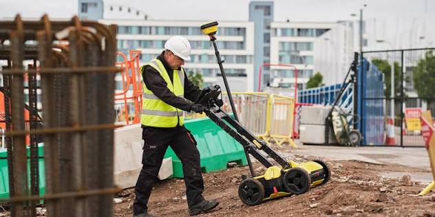
A Ground Penetrating Radar survey uses a GPR system to transmit electromagnetic pulses into the ground or another material.
When these signals encounter changes in subsurface materials, part of the energy is reflected back toward the receiving antenna.
The system records these reflections and creates data that can be interpreted to identify potential subsurface features.
In simple terms:
GPR antenna
?
Electromagnetic signal enters surface
?
Signal encounters subsurface feature
?
Reflection returns to antenna
?
Data is recorded
?
Subsurface interpretation
The resulting information can help surveyors and engineers investigate underground conditions without immediately resorting to excavation.
How Does Ground Penetrating Radar Detect Underground Utilities?
Different underground materials interact with electromagnetic waves in different ways.
For example, a buried pipe, cable, foundation or void can create a detectable change in the radar response compared with the surrounding soil.
As the GPR antenna moves across the site, it continuously collects measurements.
The resulting radar data can then be processed and interpreted.
A typical utility detection workflow is:
Site Survey
? GPR Data Collection
? Data Processing
? Utility Interpretation
? Position/Depth Assessment
? Survey Mapping
? Construction Planning
The exact ability to detect and characterize a utility depends on the ground conditions, utility material, antenna frequency, depth and other site factors.
What Can GPR Detect?
GPR can be used to investigate a wide range of subsurface features.
Potential targets include:
Underground Utilities
- Water pipes
- Sewer pipes
- Electrical cables
- Communication ducts
- Utility conduits
- Drainage systems
Buried Structures
- Foundations
- Footings
- Slabs
- Underground chambers
- Tunnels
- Buried walls
Voids and Anomalies
GPR can sometimes identify:
- Voids
- Cavities
- Disturbed ground
- Changes in soil conditions
Concrete Elements
GPR is also used in concrete investigation to help locate:
- Reinforcement
- Embedded conduits
- Pipes
- Post-tensioning elements
- Other embedded features
However, GPR does not identify every underground object with certainty. Results should be interpreted by qualified professionals and, where appropriate, verified using other information or safe exposure methods.
Why Is GPR Important for Construction?
1. Reduces the Risk of Utility Strikes
Excavating without reliable information about underground utilities can create serious risks.
Accidentally hitting an electrical cable, gas line or water pipe can lead to:
- Safety incidents
- Service disruption
- Emergency repairs
- Project delays
- Additional costs
GPR can provide an additional source of subsurface information before excavation.
2. Supports Safer Excavation
Before excavation begins, contractors can use survey information to understand potential underground obstacles.
This can help teams plan:
- Excavation routes
- Trenching
- Drilling
- Core cutting
- Piling
- Foundation work
The objective is to reduce uncertainty before breaking ground.
3. Helps Reduce Project Delays
Unexpected underground infrastructure can disrupt construction schedules.
For example:
A contractor begins excavation.
?
An undocumented pipe is discovered.
?
Work stops.
?
Engineering team investigates.
?
Design changes.
?
Construction resumes.
A pre-construction GPR investigation can help identify potential subsurface conflicts earlier in the process.
4. Non-Destructive Investigation
One of the major advantages of GPR is that it can investigate subsurface conditions without immediately digging or breaking the surface.
This makes it useful for:
- Roads
- Buildings
- Parking areas
- Concrete slabs
- Industrial facilities
- Historic structures
- Existing infrastructure
GPR Utility Detection Process
A professional GPR survey generally involves several stages.
Step 1: Understand the Project
Before visiting the site, the survey team should understand:
- Project scope
- Excavation areas
- Proposed construction
- Required survey limits
- Known utilities
- Available utility drawings
- Required deliverables
This information helps determine the appropriate survey approach.
Step 2: Review Existing Information
Available records may include:
- Utility drawings
- As-built drawings
- Previous surveys
- Site plans
- Engineering drawings
- GIS information
GPR should complement existing information rather than automatically replace it.
Step 3: Site Preparation
The survey area is assessed for:
- Accessibility
- Surface conditions
- Obstructions
- Traffic
- Safety requirements
- Existing infrastructure
The survey team then establishes appropriate scanning paths.
Step 4: GPR Data Collection
The GPR equipment is moved across the survey area.
Depending on the project, the survey can be conducted:
- On foot
- Across concrete floors
- Across roads
- Across open ground
- In utility corridors
The antenna continuously records radar responses.
Step 5: Data Processing
Collected data is processed to improve interpretation.
The workflow may include:
- Noise reduction
- Signal processing
- Data filtering
- Depth estimation
- Feature identification
- Data visualization
Step 6: Utility Interpretation
Potential utilities and subsurface anomalies are identified based on the collected data and other available information.
The survey team may classify findings according to:
- Location
- Direction
- Estimated depth
- Type where reasonably identifiable
- Confidence level
Step 7: Mapping and Reporting
Results can be presented through:
- Survey drawings
- Utility maps
- CAD files
- GIS data
- Point/location information
- GPR profiles
- Reports
The exact deliverable should be agreed before the survey.
GPR for Underground Utility Mapping
Utility mapping is one of the most valuable construction applications of GPR.
A site may contain several overlapping services.
For example:
Ground Surface
Water Pipe
Electrical Cable
Sewer Line
Communication Duct
A GPR survey can help identify subsurface anomalies and trace potential utility routes.
However, underground utility detection can be complex.
Some utilities may be difficult to detect because of:
- Depth
- Soil conditions
- Utility material
- Signal attenuation
- Nearby infrastructure
- Surface conditions
- Electromagnetic interference
Therefore, survey results should be treated as professional survey information rather than a guarantee that every buried object has been detected.
GPR for Concrete Scanning
GPR isn’t limited to soil and underground utility detection.
It can also be used to investigate concrete structures.
Before drilling or cutting into concrete, contractors may need to understand what is embedded inside.
Potential targets include:
- Rebar
- Electrical conduits
- Pipes
- Post-tensioning components
- Voids
- Structural elements
This can be particularly useful before:
- Core drilling
- Saw cutting
- Anchoring
- Penetrations
- Demolition
- Structural modifications
GPR vs Traditional Excavation
Traditional excavation physically exposes underground infrastructure.
While excavation may eventually be necessary for verification, it is not always the best first step for locating potential utilities across an entire site.
GPR
- Non-destructive
- Rapid investigation
- Can cover large areas
- Helps identify subsurface anomalies
- Supports pre-construction planning
Excavation
- Physically exposes infrastructure
- Can provide direct verification
- More disruptive
- Requires additional time and resources
- May damage existing infrastructure if poorly planned
In many situations, the most effective strategy is:
Existing Records
GPR Survey
Other Detection Methods
Targeted Verification
rather than relying on only one source of information.
GPR Limitations
GPR is a powerful technology, but it isn’t a universal underground detection solution.
Soil Conditions
Certain soils can significantly reduce radar penetration.
Clay-rich or highly conductive soils may attenuate the radar signal.
Depth
Detection capability decreases as depth increases, and the practical depth varies significantly depending on the ground and equipment.
Material
Different materials produce different radar responses.
Some objects may be difficult to identify or classify confidently.
Congested Areas
A site containing many closely spaced utilities can make interpretation more complicated.
Interpretation
GPR data requires experience.
A radar response doesn’t automatically mean:
“This is a water pipe.”
Professional interpretation considers:
- Signal characteristics
- Geometry
- Site information
- Existing drawings
- Utility patterns
- Other survey data
How Deep Can GPR Detect?
There is no single maximum depth for GPR.
Detection depth depends on:
- Antenna frequency
- Soil conditions
- Ground conductivity
- Target size
- Target material
- Surface conditions
- Required resolution
Generally, lower-frequency antennas can provide greater penetration but lower resolution, while higher-frequency antennas provide greater resolution but shallower penetration.
Therefore, the antenna should be selected according to the project’s target depth and required resolution.
GPR Survey vs Utility Records
Construction teams should not assume that existing utility drawings are always complete or accurate.
Older facilities may have:
- Missing drawings
- Outdated drawings
- Unrecorded modifications
- Abandoned services
- Inaccurate utility locations
GPR can provide an additional layer of site information.
A stronger workflow is:
Historical Drawings
?
Visual Site Inspection
?
GPR Survey
?
Utility Mapping
?
Verification
This provides a more comprehensive understanding of existing conditions.
GPR + 3D Laser Scanning
GPR and 3D laser scanning can complement each other.
3D Laser Scanning
Captures:
Above-ground geometry
Such as:
- Buildings
- Walls
- Floors
- Structural elements
- Equipment
- MEP systems
GPR
Investigates:
Below-surface / embedded features
Such as:
- Underground utilities
- Concrete reinforcement
- Embedded services
- Voids
- Subsurface anomalies
Together, they can provide a more complete picture of the physical environment.
GPR + BIM
GPR survey information can also contribute to digital construction workflows.
A possible workflow is:
GPR Survey
?
Utility Mapping
?
CAD / GIS Data
?
BIM Coordination
?
Construction Planning
This can be particularly useful during renovation and retrofit projects where existing utility information needs to be coordinated with proposed design.
GPR Applications Across Industries
Although construction is a major application, GPR can be useful across several sectors.
Construction
- Utility detection
- Excavation planning
- Concrete scanning
- Foundation investigation
Infrastructure
- Roads
- Bridges
- Tunnels
- Utility corridors
Industrial
- Plant modifications
- Underground services
- Concrete structures
- Facility upgrades
Commercial Buildings
- Renovation
- MEP installation
- Core drilling
- Structural modifications
Heritage
- Non-destructive investigation
- Buried structures
- Historic building assessment
When Should You Conduct a GPR Survey?
A GPR survey can be considered before:
- Excavation
- Trenching
- Drilling
- Piling
- Foundation construction
- Road construction
- Utility installation
- Demolition
- Structural modifications
- MEP installation
The earlier subsurface uncertainty is addressed, the easier it can be to incorporate findings into construction planning.
How Much Does a GPR Survey Cost?
GPR survey pricing varies by project.
Factors can include:
- Survey area
- Location
- Site accessibility
- Ground conditions
- Required depth
- Required resolution
- Number of targets
- Utility density
- Data processing
- Mapping requirements
- Reporting requirements
A small concrete scanning project and a large infrastructure utility survey can have very different costs.
For this reason, a professional provider should assess the project before providing a quotation.
How to Choose a GPR Survey Company
Before hiring a provider, ask:
1. What type of GPR equipment do you use?
2. What depth range is realistic for my site?
3. Can you map underground utilities?
4. Do you provide CAD/GIS deliverables?
5. Can GPR data be integrated with existing survey information?
6. Do you provide concrete scanning?
7. Can you combine GPR with 3D laser scanning?
8. How do you validate detected utilities?
9. What level of accuracy can you provide?
10. What will the final report contain?
A good provider should be transparent about both capabilities and limitations rather than promising that GPR will detect every underground feature.
Frequently Asked Questions
What is GPR surveying?
GPR surveying uses electromagnetic radar signals to investigate subsurface conditions and identify potential buried features, utilities and anomalies.
Can GPR detect underground pipes?
Yes, GPR can detect many types of buried pipes and other utilities, although detection depends on depth, material, soil conditions and other factors.
Can GPR detect electrical cables?
GPR can help identify underground electrical infrastructure, particularly when combined with other utility-detection techniques and available records.
Can GPR detect gas pipes?
GPR may detect physical features associated with buried gas infrastructure, but it should not be treated as a guaranteed gas-pipe detection method. Appropriate utility locating and verification procedures remain important.
Can GPR detect rebar?
Yes. GPR can be used to locate reinforcement and other embedded features within concrete.
Is GPR better than excavation?
GPR is non-destructive and can help investigate large areas before excavation. However, physical exposure may still be required to verify certain utilities or conditions.
How accurate is GPR utility detection?
Accuracy varies depending on equipment, ground conditions, target characteristics, survey methodology and interpretation. Professional survey results should clearly communicate estimated locations and limitations.
Can GPR data be used with BIM?
Yes. Utility information obtained through GPR can potentially be incorporated into CAD, GIS and BIM workflows depending on the project requirements and available data.
Conclusion
GPR surveying provides construction and engineering teams with a non-destructive way to investigate subsurface conditions before excavation, drilling and other intrusive work.
By identifying potential underground utilities, embedded objects, voids and other subsurface anomalies, GPR can help teams make better-informed decisions during construction planning.
However, GPR is not a magic solution that detects every underground object in every environment. Its performance depends on soil conditions, target characteristics, depth, antenna selection, site conditions and professional interpretation.
For complex projects, combining GPR with 3D laser scanning, conventional surveying, existing utility records and targeted verification can provide a more comprehensive understanding of existing conditions.