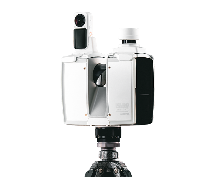
Focus i.1 Terrestrial Laser Scanner Series
The Focus i.1 Terrestrial Laser Scanner Series delivers fast, accurate reality capture and connected workflows, helping teams create reliable digital representations and turn field data into project insight.
Focus i.1 and Focus i.1 X help teams capture reliable data, add real-world context, and move from field capture to connected project insight with confidence.
Core Value Proposition
Build on data you can trust — accuracy, colour and positioning in one connected workflow.
Build on Trusted Data
Capture reliable measurement data for planning, investigation, documentation, and decision-making. With up to 0.9 mm object scanning accuracy, Focus i.1 and i.1 X help teams build confidence in every result.
Richer Deliverables, Faster Capture
Capture colorized scan data in around 20 seconds per scan position with the included Insta360 X6, supporting up to 120 MP color information for richer visual context.
Place Data in Real-World Context
Focus i.1 supports LiDAR-based tracking through an attachable localizer, while Focus i.1 X includes a GNSS/RTK receiver for georeferencing with GIS, Esri, and other mapping environments.
Keep Projects Moving
In-field pre-registration and real-time position tracking help users validate data completeness, reduce rework, and move faster to deliverables with FARO Sphere® XG.
Choose your version
FARO® Focus i.1
PrecisionBuilt for professionals who need exceptional accuracy and confidence in every scan — the precision required for demanding survey-grade, AECO, and public safety workflows.
- Range (90% white)
- 0.5 – 200 m
- Positioning
- Attachable localizer · 360° LiDAR tracking
- Included
- Insta360 X6 PanoCam + localizer
- Best for
- Survey-grade, AECO & public safety
FARO® Focus i.1 X
GeospatialExtends the precision of Focus i.1 to large-scale outdoor and geospatial projects, aligning data to real-world coordinates in the field.
- Range (90% white)
- 0.5 – 400 m
- Positioning
- GNSS/RTK receiver · real-time georeferencing
- Included
- Insta360 X6 PanoCam + GNSS/RTK receiver
- Best for
- Large outdoor & geospatial sites
Technical Capabilities
Survey-grade precision
Object scanning accuracy up to 0.9 mm at 20 m, 3D accuracy of 2 mm at 10 m and up to 2 million points per second — with LaserHDR and a co-axial colour unit that minimises parallax.
- In-field pre-registration and live position tracking in Stream™
- Up to 266 MP internal colour, 120 MP with external PanoCam
- Cloud processing and collaboration in FARO Sphere® XG
Technical Specifications
| Range (90% white) | 0.5–200 m (i.1) · 0.5–400 m (i.1 X) |
|---|---|
| Max speed | Up to 2 MPts/sec |
| 3D accuracy | 2 mm @ 10 m, 3.5 mm @ 25 m |
| Object scanning accuracy | 0.9 mm @ 20 m |
| Colour resolution | Up to 266 MP internal · 120 MP PanoCam |
| Ranging error | ±1 mm |
| Angular accuracy | 19 arcsec |
| Battery life | About 4 hours |
| Weight | 4.4 kg (incl. battery) |
| Size | 230 × 183 × 103 mm |
| Protection | IP54 · Laser class 1 |
| Warranty | 2 years (manufacturer) |
Need help choosing?
Our scanner specialists can recommend the best model for your project requirements.